The southern border of the land of Israel is a desert. It continuously changed during biblical times, and that is according to the Jewish settlement in the southern part of Israel, the Negev, and according to the relations with the neighboring kingdoms, mainly Egypt and Edom.
Since the permanent settlements depend for their living mainly on the water sources, the permanent settlements in the Negev were concentrated in the Beer Sheva Valley, which is rich in groundwater, and thus its inhabitants were fed mainly from well water and made a living from raising grain and sheep. The 2nd zone of settlement in the Negev was in the west of the northern and central Negev mountains, from the watershed of the mountains and west. There they engaged in flood farming, that is, in the cultivation of grains and vines on the steps of the streams, and in raising sheep. From the watershed of the mountains and to the east, in the more arid region, with very little precipitation, stretched the Biblical desert area, where very little could be raised.
In the Arava Valley, where the main longitudinal trade route of the Negev passed, settlements were established that served the trade convoys. These settlements were founded only at sites and junctions, where springs of water exited, such as Etzion Geber and Eilat on the shore of the Red Sea, Khirbat Faynan, known by the Romans as Phaino in the east side of the Jordan river, where there were large copper mines, and near Ein Hatzeva is the Biblical settlement of Tamar which was the important junction of the trade convoys in the Arava Valley.
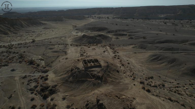
We are a kilometer north of Ein Hatzeva, in the biblical settlement Tamar or Tamara as it was called in the Roman period, 1,000 years after its establishment in the time of King Solomon. The settlement existed throughout the kingdom period and for a total of approximately 1,500 years, from the time of King Solomon until the end of the Byzantine period. Today we will focus on Tamar during the kingdom period until the destruction of the First Temple in Jerusalem in 586 BC, an exciting period in the history of the biblical settlement of Tamar.
What held Tamar an active settlement for such a long time? The sources show that roads along a given route were used by the ancient civilizations for thousands of years. In the Hebrew Bible, there are descriptions of different roads such as the king’s road, the Philistine Road, the mountain road, and others. The more the historical kingdoms adopted the principle of permanent settlements, and the more they maintained broad policy frameworks and commercial and cultural ties between political entities, the more significant the traffic became. Planning and maintaining a road were not an easy task then and I will add that it is not an easy task today either. A regime that was interested in establishing a new road,
was required to expropriate land from residents, and this did not pass easily even to strong and established regimes, therefore, it was customary to preserve the route of ancient roads for hundreds and thousands of years.
The proximity of the site to the ancient kingdom of Edom which stretched east of the Arava stream, and as I mentioned the border changes with the periods, making it difficult to associate some of the remains found here with national and political entities.
There are three aspects to the importance of Tamar’s location:
The 1st: the site is located at an important crossroads: here passed the road as it does today, 3,000 years after the establishment of Tamar, to the Dead Sea and Ein Bokek and it continues to Ein Gedi and Jerusalem. Same road is going south to Yotveta and Eilat. Another road crosses here, this time from the southeast, from the copper mines in Phaino to the west through Ma’ale Akrabim or “Scorpions Ascent” in English and to Mamshit to the north of the Negev. We are at a strategic crossroads.
The 2nd: the site is located close to Ein Hatzeva Spring, in Arabic Ein Husub which means the spring of abundance, which is one of the abundant springs in the central Arava. In the 1960s, water drilling caused the groundwater level to drop and the spring to dry up. Today only the large and ancient jujube tree, several hundred years old, indicates the place of the spring. It is difficult to determine with certainty the age of the tree because the jujube tree does not form annual rings in the trunk.
The 3rd aspect to the importance of Tamar’s location: the proximity of the site to the biblical Land of Edom which stretched east of the Arava stream, suggests that the place served as an important military and administrative center. According to the findings, the site was used throughout the kingdom period until the destruction of the First Temple, and then during the Nabatean period and during the Roman period.
The place was excavated by archaeologists over several decades and findings were discovered here from the 10th century BC, the period of King Solomon, and untill the end of the Byzantine period or the beginning of the Arab period. Findings from six different periods were discovered. Today we will focus on three periods that are all between the period of King Solomon and the destruction of the First Temple in 586 BC. According to most scholars, the site is identified with the biblical Tamar, which is mentioned in the Hebrew Bible (Genesis 14:7, Ezekiel 47:19) and as one of the cities built by King Solomon (1Kings 9:18). The place was abandoned at the end of the Byzantine period.
The 1st period: 10th century BC – the remains of a fortress from the days of King Solomon were found at a depth of 3.5m below the gate area and part below a mud brick silo. I repeat the third reason for the importance of the place in Solomon’s time – The fort was part of a system of forts built by Solomon
to protect the southern border of his kingdom and to supervise the important roads in the southern regions.
The 2nd period: 9th and 8th centuries BC – the remains of a very large fortress were uncovered above the remains of the ancient fortress. It was a square fortress whose sides were about 100m long each, and its area about 10 dunams, equivalent to 2.5 acres. The fortress was surrounded by a sort of a double wall where the external wall is also used as the wall of an internal room. In the three corners of the fortress, the remains of towers were found. The stones for building the structure were quarried in Hatzeva brook a few kilometers from here.
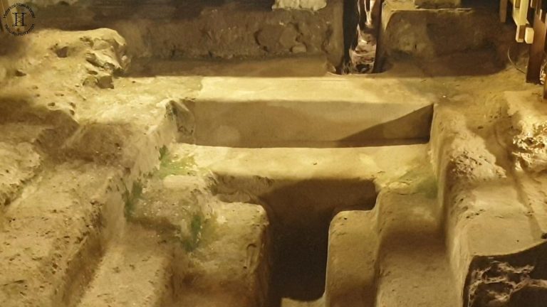
The gate of the fortress was set in the northeast corner. On both sides of the gate passage, two cells were built on each side, a structure identical to what we have seen at several sites such as Bethsaida and the ruins of Qeiyafa, which are from the same period. Also, inside the gate complex, in its southwestern corner, remains of three parallel walls were uncovered, it seems that this is the warehouse wing, near which two silos were uncovered, where charred remains of wheat and barley kernels were found. The silos were walled with plaster in order to prevent moisture and rodents from entering.
This fortress is one of the largest fortresses from this period in the Negev, the south of Israel. In light of the large area of the fortress, it is possible that we have a fortified city and not necessarily a fortress. The strategic importance of the fortress is well reflected in its size and strength of fortification. Which of the kings of Judah initiated its establishment? The common opinion is Uzziah also known as Azariah. As it is written in the 2nd book of Kings (14:22): “He built Eilat and returned it to Judah.”
Uzziah was working to control the trade routes and thus to make the transportation of goods in the region more efficient and no less important – increase his kingdom’s income from controlling the trade routes. For this purpose, he regains control over Ashdod and Yavneh since the split between the kingdom of Judah and the kingdom of Israel. He built settlements and fortresses along the sea coast, which created control over the ports, and supervision over the Philistia Road between Egypt, Judah and Israel kingdoms. Control over Philistia, Kadesh and Eilat gave Uzziah control over the route that carried goods between the Gulf of Eilat and Philistia, and control over all the trade routes that led from Egypt to the north. The 2nd book of Chronicles (26: 9-15) further describes Uzziah actions as “Strengthening Jerusalem”. Also, “building towers in the desert, and the digging of cisterns” – this means is that he constructed a defense line fortification that secured the relatively desolate area between the Arava and the Judean Foothills. An important question is what led to the destruction of the fortress and when? Was the fortress destroyed as a result of the great earthquake described in the prophecy of Amos? Or was it destroyed in a violent struggle with Edom, Judah’s neighbor to the southeast?
The prophet Amos explicitly states that the beginning of his prophesy was “in the days of Uzziah, king of Judah, and in the days of Jeroboam son of Joash, king of Israel, “two years before the earthquake” (Amos 1:1). Biblical scholars and historians attribute the earthquake to approximately 760 BC. According to the findings of scientific research, the intensity of the earthquake was about 8 on the Richter scale.
The 3rd period: 7th and 6th centuries BC – The final destruction of the fortress in the third period, probably occurred in or around 735 BC, during the reign of King Ahaz of Judah (2Kings 16). According to the Bible, both northern kingdoms: Israel and Aram, as well as the neighboring nations to the southwest and southeast: meaning the Philistines and the Edomites (2Chronicles 25:17-18) were in a military conflict with the kingdom of Judah. According to several researchers, the Edomites rebuilt the fortress after destroying it when they occupied the place. This ended Judah’s hold on this southern stronghold.
This may explain the variety of Edomites ritual vessels on the north side of the site. During this period, a rare find was discovered on the site: a burial of a small temple, which was outside the walls of the fortress, containing ritual vessels and clay figurines, all broken and buried.
The excavations at Tamar illustrate the importance of the site during the kingdom period. There is a follow up video describing to site and its history during the Nabataean period and the Roman period.
And to conclude as usual I have a question for you: In the Hebrew Bible, what is the family connection between Edom and Israel. The answer will appear at the end of the video.